
Commercial Feature
Ancient Egypt and the Eternal Nile: How Geography Shaped a Civilization
Ancient Egypt was shaped more by its geography than anything else. The Nile River and the deserts that frame it defined Egypt’s agriculture, religion, politics, and architecture. The Nile was not just a source of water—it was the heart of Egyptian life and remains so to this day. For history buffs and travelers planning to visit Egypt, understanding the country’s unique geography adds depth to the monuments, cities, and culture that still amaze the world.
The Nile River: Lifeblood of Egypt
The Nile, flowing north from East Africa to the Mediterranean Sea, is over 6,000 km long and the longest river on earth. In ancient times its annual flooding between June and September would transform the surrounding land. When the waters receded, they would leave behind a layer of black silt, which made the soil incredibly fertile.
This fertile zone, known as the Black Land, was where they would grow wheat, barley, flax for linen, and papyrus for writing and construction. Beyond this narrow green strip was the Red Land—the deserts that, while barren, played their own important role.
Unlike many rivers in other ancient civilizations, the Nile’s flooding was regular and predictable. This allowed the Egyptians to develop advanced agricultural techniques and a calendar based on the river’s rhythms. The resulting food surplus led to a growing population, thriving cities, and specialized trades.
Even today, around 95% of Egypt’s population lives near the Nile. Its importance is as enduring as the monuments built along its banks.
The Division of Upper and Lower Egypt
Ancient Egypt was divided into two regions, not north and south but based on the Nile’s flow.
- Upper Egypt was the southern region where the river cut through narrow valleys and high cliffs.
- Lower Egypt was the northern region where the Nile Delta branched out before meeting the Mediterranean Sea.
Around 3,100 BCE these two regions were united under the first pharaoh, who established the capital near Memphis at the border of the two lands. This was the beginning of a centralized kingdom that would last for thousands of years.
The Nile was the natural transportation route between these regions. Boats carried goods, people, and ideas and helped to unify the culture and strengthen the political structure.
Deserts as Shields and Sources of Wealth
The Eastern and Western Deserts around the Nile were not just empty spaces. They were natural fortresses, protecting Egypt from invasions and contributing to the country’s long stability.
These deserts also had mineral wealth. Ancient Egyptians mined for gold, copper, and precious stones, which funded temples, tombs, and trade expeditions.
To the south, a series of natural rock formations in the Nile called cataracts controlled trade and contact with Nubia. Meanwhile, scattered oases in the deserts supported trade caravans going to and from sub-Saharan Africa, allowing cultural exchange and commerce beyond Egypt’s borders.
The Nile’s Sacred Role in Religion and Culture
For the people of ancient Egypt, the Nile was a divine force. It was celebrated in myths, honored in festivals, and personified by gods such as Hapi, the god of the annual flood. The river’s cycle of flooding and renewal became a symbol of life, death, and rebirth—concepts that shaped Egyptian religion, especially the afterlife.
Most major cities and sacred structures were built near the Nile. The ancient capital of Thebes, the temples of Luxor and Karnak, was built beside the river. On the west bank, where the sun died each evening, the Egyptians buried their pharaohs in the Valley of the Kings. Geography and spirituality were one in the Egyptian mind.
How to Experience Egypt’s Geography Today?
Today you can still see the connection between Egypt’s environment and ancient civilization. Must-see destinations are
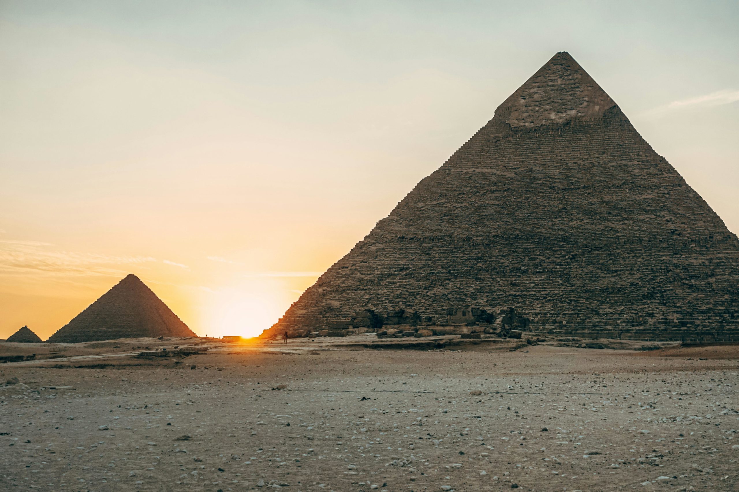
- The Great Pyramids of Giza and the Sphinx, standing proud on the west bank of the Nile near Cairo
- The Egyptian Museum in Cairo, housing many treasures shaped by Nile life
- The temples of Luxor and Karnak, on the east bank of the river
- The Valley of the Kings, where many Pharaohs were laid to rest in tombs carved into desert cliffs
- A Nile River cruise, a relaxing and scenic way to see ancient landscapes and riverine villages
In 2023, over 13 million people visited Egypt. Many chose Nile cruises or Egypt tours that followed the footsteps of the civilization shaped by the river.
Travel Tips for Visiting Egypt
To fully enjoy your journey, consider the following practical advice:
- Best time to visit: October to April is the coolest.
- Clothing: Light and breathable for day and layers for night
- Hydration and sun: Dry climate means plenty of water, sunscreen, and a hat.
- Local guides: Experienced guides will bring history and geography to life.
- Itinerary: Choose tours that cover Upper and Lower Egypt to see the regional differences.
The Lasting Legacy of Geography
The story of Ancient Egypt is the story of the Nile. The river’s floods, cycles, and central location allowed a great civilization to rise. The deserts protected and nourished it. Together these geographical features gave Egypt a strong base upon which to build remarkable achievements in architecture, science, religion, and government.
Today, whether you are sailing down the Nile, visiting ancient tombs, or gazing at the pyramids, the landscape tells a timeless story. Knowing how geography shaped ancient Egypt adds depth to every experience and reminds us how the natural world still shapes our destiny.
 News / Unprecedented Union presidential race delivers re-open nominations result18 March 2026
 Theatre / Faith, doubt, and sanctity in Hamlet in the Chapel18 March 2026
 News / Union elections underway with only one position contested14 March 2026
 News / Former Union debates officer cleared of misconduct19 March 2026
 Features / How rising food costs are changing student life 18 March 2026
 Fashion / A Walk of Becoming: looking back on CUCFS 202620 March 2026
 News / Write for Varsity this Easter20 March 2026
 Arts / Reviewing the Cambridge Review of Books20 March 2026
 Interviews / Antony Stokes on the Foreign Office, Mars and LinkedIn 19 March 2026
- News / Former Union debates officer cleared of misconduct19 March 2026