
Geology Rocks: Digging beneath the surface
Eloise Matthews takes us on a whistle-stop tour through space and time, explaining the what, how, and why of three of the most famous geological sites on Earth: Uluru, the Grand Canyon and Yosemite National Park.
From the smallest mineral fragment to the structure of an entire planet, geology is accessible to marvel at and question anywhere, anytime. Rocks are archives of our planet’s dynamic history, and large structures found across the continents tell stories of the factors affecting each location over time.
In this article I aim to break down the formation processes of some geological wonders I have been fortunate enough to visit. The underlying trigger to most of these formations are orogenic events, which are when Earth’s crust undergoes deformation resulting in large scale geological change, such as significant mountain building. The landscapes are then eroded to produce the formations we see today.
Uluru (Ayers Rock)
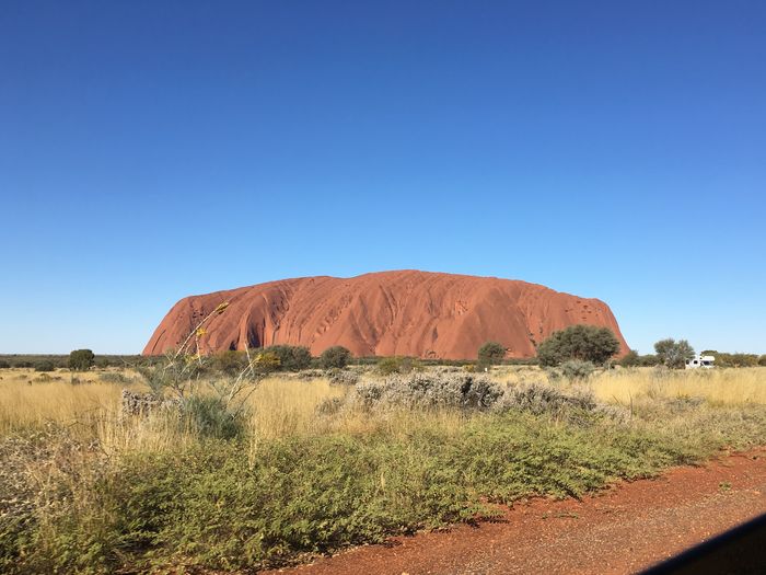
Indigenously named Uluru, Ayers Rock and its sister formation Kata Tjuta, also known as the Olgas, are found in the desert of Australia’s Northern Territory.
“The changes land has undergone to reach its present states is immense, and the corresponding history is embedded beneath our feet. ”
Sediment deposited in the Amadeus Basin buckled during the Petermann Orogeny. Occurring within the Australian plate, this event is unique as orogenies usually occur at plate margins when two separate sections of crust meet. The orogeny has been dated to around 550 million years ago, but its cause is still being actively investigated.
A second orogenic event, the Alice Springs orogeny, is responsible for tilting the layers of sedimentary rock - compressed accumulations of particles - to the extent observed today, which is almost vertical in Uluru. This took place between 350 and 400 million years ago. Since then, erosion of surrounding sediment has revealed the more resistant arkose, a sandstone, of Uluru, and the conglomerated boulders, pebbles and sand of Kata Tjuta – however these formations are thought to be only the tips of much larger sections of these rocks which actually extend deep into the Earth.
Despite its desert location, Uluru boasts a number of waterholes. Arguably the most captivating is the Mutitjulu waterhole which displays indigenous artwork on the surrounding rock and a crystal clear reflection of the red sandstone above it – the red colour is obtained from iron oxide impurities in the rock. Whilst most water in the area is from groundwater supply, unpredictable rainfall, averaging at approximately 30cm per year, can contribute to the waterholes, carving paths down the side of Uluru.
Grand Canyon

A canyon is a steep-sided erosional valley – the Grand Canyon in Arizona is 1800m deep and is today shaped by the Colorado River, much like the rainfall cascading down the side of Ayers Rock carves a path; but this is certainly a much larger scale.
The strata, layers of rock, of the Colorado Plateau, in which the Grand Canyon is carved, consist of all three categories of rock. Deepest in the canyon are the Vishnu Basement Rocks, which are igneous and metamorphic in nature. Igneous rocks are cooled volcanic magma, and when these (or sedimentary, for that matter) are subject to heat and pressure they become metamorphic, deformed with adjusted properties.
Above these basement rocks, the Great Unconformity is then present; an unconformity is where a period of time is “missing” in the geological sequence between two points. This particular one was named in the Grand Canyon by explorer John Wesley Powell in 1869, but is observed worldwide and thought to be of great significance, perhaps even a trigger of the Cambrian Explosion - the dramatic diversification and appearance of animals in the fossil record such as those with exoskeletons and other hard parts, with a wealth of modern descendants.
“The Grand Canyon is undergoing subtle but significant change today, which may be amplified in future by climate change.”
This proposal has been suggested due to the changes in ocean chemistry that the gradual establishment of the unconformity caused. Newly advancing and retreating shallow seas in the early Cambrian period eroded surface layers, revealing never previously exposed crustal rocks, which, when chemically weathered, released ions that make up key biominerals. The process of biomineralisation would have been favoured as it enabled organisms to balance levels of these new ions, thus explaining the apparent diversification of animals in the rock record as hard parts could be preserved. However, it is still greatly debated whether animals truly diversified around this point in time or if pre-existing ones were now just more easily fossilised.
In the Grand Canyon specifically, the Great Unconformity is an example of a nonconformity as it consists of sedimentary rocks overlying metamorphic ones, illustrating a gap in time between periods of metamorphism and those of almost ‘casual’ sediment deposition. These horizontal sedimentary layers are simply the result of deposition from variations in sea level – for example, the top layer of the modern canyon is Kaibab Limestone, diagnostic of a shallow marine environment. It is also rich in marine fossils such as brachiopods, amongst others, although it is illegal to remove fossils from the National Park. With the Grand Canyon being one of the best displays of the Great Unconformity worldwide, and hosting such a range of fossils, it is significant not only geologically, but also biologically.
Before the establishment of the San Andreas transform fault we know today, where the Pacific plate and North American plate move in opposite directions side by side, an oceanic plate called the Farallon plate was subducting beneath the North American plate. This is when a more dense oceanic plate sinks beneath another, usually continental, plate upon meeting it, due to their relative motion atop the Earth’s mantle due to convection currents. An associated orogenic event spanning 40-70 million years ago, the Laramide orogeny, is largely responsible for the uplift of the Colorado Plateau. The oceanic plate also melts as it heats up, providing fuel for volcanic activity explaining the presence of igneous rocks.
As is common is desert locations, irregular, heavy rainfall can cause erosion of the edge of the canyon. The plants in the area have shallow roots in order to quickly collect this rain, so this means the sediment is not anchored by roots and more easily eroded. Therefore, the Grand Canyon is still undergoing subtle but significant change today, which may be amplified in future by more turbulent weather patterns due to climate change.
Yosemite National Park

Roughly 430 miles North West of the Grand Canyon, deep in the Sierra Nevada mountains of California, lie the breath-taking views of Yosemite National Park. The Nevadan orogeny approximately 150 million years ago, also associated with Farallon plate subduction is responsible for the primary uneven landscape and the widespread igneous intrusions - a 300 mile long collection of cooled magma intrusions, forming a structure we call a batholith, runs through the Sierra Nevada mountains.
“The steep sides have then been smoothed by the movement of subsequent smaller glaciers, and are today appealing surfaces for daring climbers”
The geological foundation of Yosemite is the resulting bed of granite, exposed over time by erosional processes. 5% of exposed rocks in Yosemite are metamorphic, which have formed due to heating and slight deformation due to the granite intrusions – a process known as contact metamorphism.
In the last million years, glaciation has been the most notable factor shaping Yosemite, carving out a magnificent U-shaped valley in the granite. The onset of the Quaternary period’s Ice Age due to falling CO2 levels, coupled with tectonic uplift and thus higher altitudes, led to such low temperatures. Due to the sheer weight of the ice and snow, glaciers progress downslope under gravity – uplift tilted the area towards the west, providing this slope – and erode their surroundings as they move. Ice is softer than rock so is incapable of eroding the rock by itself, particularly a hard, erosion resistant rock such as granite which has a high quartz content, a resistant mineral. The erosive force is actually previously eroded material trapped in the edges of the glaciers.

The steep sides have then been smoothed by the movement of subsequent smaller glaciers, and are today appealing surfaces for daring climbers, for example the striking Half Dome which reaches over 2.5km above sea level. Yosemite was declared a National Park in 1890 and a World Heritage Site just under a hundred years later.
With international travel still largely off-limits, a travel-based geology article is perhaps irksome, though the wanderlust is doubtless understandable. However, there is always lots to appreciate about one’s own local geology - take Cambridge, for example, the most commonly accessible geology for the University’s international cohort. Initially unexciting beds of sediment, eroded flat, are actually part of an unconformity between rocks from the Cretaceous and Jurassic periods, dated at 100 million years on average - back when dinosaurs roamed. The temporal scale of our planet’s history is staggering, as is the spatial; the changes areas of land have undergone to reach their present states are immense, and the corresponding history is embedded beneath our feet.
 News / C4P vandalises University offices over divestment10 June 2026
 Lifestyle / A town with a view11 June 2026
 Comment / Top of the slops: the competitiveness of college dining4 June 2026
 Sport / The imperfect privilege of Cambridge sport12 June 2026
 Comment / ‘On the Poverty of Student Life’: sixty years on10 June 2026
 Music / Hejira: a jazzed tribute to Joni Mitchell 13 June 2026
 Film & TV / Lights, camera, Cambridge13 June 2026
 Lifestyle / Confessions of a May Ball crasher12 June 2026
 Lifestyle / May Week horoscopes12 June 2026
 Lifestyle / The finalist’s bucket list12 June 2026