Is the Arabian Sea coast at risk of a tsunami?
In a politically volatile region, carrying out potentially life-saving research can be a challenge

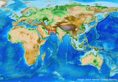
The Makran: a thousand-kilometre stretch of desert at the northern end of the Arabian Sea, it was hostile enough to kill Alexander the Great’s army, mired in geopolitical complexity, and on the Foreign Office “advise against all travel” list. Not, perhaps, the first place you would think of as a field area for an Earth Sciences PhD.
From a geophysics perspective, however, the Makran’s inaccessibility makes it an interesting challenge. As part of my PhD I have been looking at the possibility of a large earthquake and associated tsunami in the region. Although I haven’t been able to go there on fieldwork (the “advise against all travel” issue), by combining techniques based on remote observation – from Google Earth to global measurements of earthquakes – with precise GPS measurements made by colleagues in Iran, I’ve still been able to make progress in understanding how the area works.
The Makran is a subduction zone – where one tectonic plate is pulled beneath another. In this case, the Arabian plate, which makes up the floor of the Arabian Sea, is being pulled, “subducted”, beneath the southern coasts of Iran and Pakistan. There are lots of interesting questions associated with subduction zones – but the most important one for people living in the area is: can this subduction zone produce large earthquakes? (If you’re interested in the other questions have a look at my recent paper.)
Earthquakes happen in subduction zones because as one plate is pulled beneath another, the surfaces do not slide freely. Effectively, two massive pieces of not-necessarily-smooth rock are sliding past each other. If these rocks get stuck then stress starts to build up. At some point, the rock will break, causing the plates to jerk past each other, and this is what generates an earthquake.
“Karachi, a megacity with over 27 million inhabitants, could be threatened by both a subduction earthquake and any associated tsunami”
The reason why earthquakes in subduction zones are important, even for people living as far away as the opposite side of the Pacific Ocean, is the waves they generate. A subduction zone earthquake moves the whole seafloor, displacing a huge quantity of water and starting a wave with a wavelength much deeper than the ocean. These “tsunamis” do not lose energy as they travel, so can cause devastation even thousands of kilometres from their source. This was what happened after the Boxing Day earthquake in Sumatra in 2004, when tsunami waves caused deaths as far away as Somalia.
The Sumatra 2004 earthquake was a magnitude 9. An earthquake 10 times smaller than this (magnitude 8 – the scale is logarithmic) happened in the eastern (now Pakistani) Makran in 1945, but we don’t have any historical record of earthquakes occurring in the western (Iranian) part of the subduction zone. However, we also know that historically few people have lived in the region, so it’s possible that there have been earthquakes, but no people to write about them.
Much of the Makran’s interior is still sparsely inhabited, but the coastal regions, and those of other countries bordering the Arabian Sea, are not. Karachi, at the eastern end of the subduction zone, is a fast-growing megacity with over 27 million inhabitants and could be threatened by both a subduction earthquake and any associated tsunami. The at-risk population, and potential economic costs, of such an earthquake look set to increase in the near future as China invests in Pakistani coastal infrastructure and India in Iran’s.
Working with colleagues in Iran, I have been using a range of different techniques, in particular GPS, to try to work out whether the Arabian plate is sliding smoothly under the Iranian coast, or is stuck and could produce an earthquake. The GPS we use is essentially a more accurate, fixed-location version of the technology in smartphones and can be used to measure how fast the surface of the Earth is moving to within about a millimetre per year. By modelling what velocities we would expect from the freely-sliding and stuck scenarios we concluded that our measurements are consistent with the Arabian plate being stuck.
Putting out GPS stations in the Makran is a difficult task, so at the moment we can only say that all the data are consistent with the Makran being able to produce an earthquake as big as Sumatra 2004 if the whole of the Arabian plate were to slip in one go. Without a historical record we can’t say how often such large earthquakes might happen, so it is important that people living in the Makran and near the coast are prepared for the worst case scenario.
A tsunami warning system is already in place around the region, and a test in 2014 for a magnitude 9 earthquake along the Makran is a step in the right direction. By continuing to work with colleagues to refine our understanding of this area and to ensure that the public, as well as governmental organisations, are aware of the hazard, I hope that we can prevent any future earthquakes in the Makran from becoming disasters
 Interviews / Lord Leggatt on becoming a Supreme Court Justice21 January 2026
 Features / Are you more yourself at Cambridge or away from it? 27 January 2026
 News / Reform candidate retracts claim of being Cambridge alum 26 January 2026
 News / Report suggests Cambridge the hardest place to get a first in the country23 January 2026
 News / Cambridge psychologist to co-lead study on the impact of social media on adolescent mental health26 January 2026


